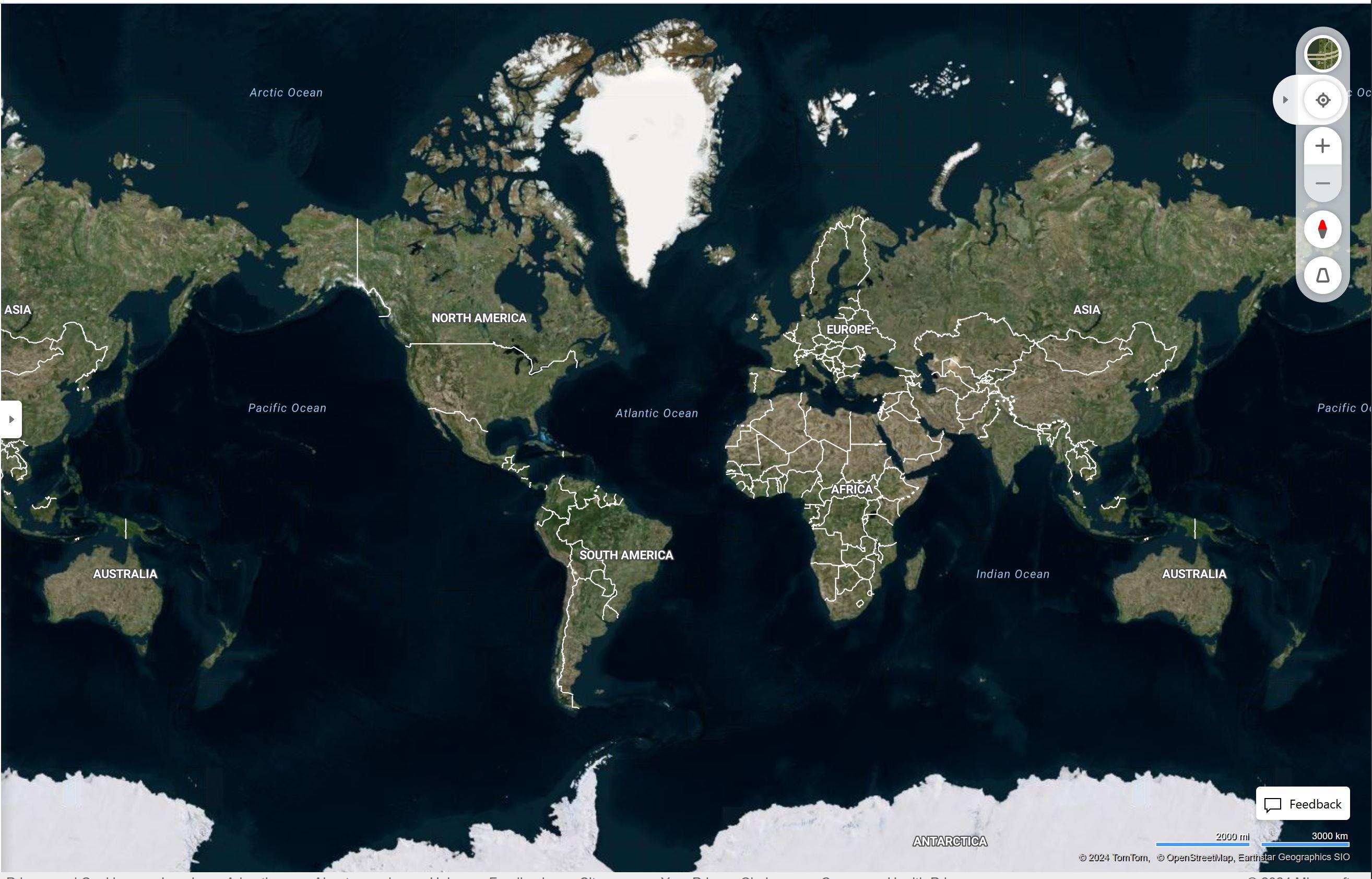
The Antarctic is colder than the Arctic, yet for some reason there is more sea ice in the north leading to it not being shown on maps. Oh, and the only glaciers depicted are in Green land, so named for reasons. And no detailed topography. That doesn’t make much sense.
(media.conspiracies.win)
Speculation
What exactly is the issue and why is it an issue?
Have you actually looked this up ("done research") or are you just looking at a map and decide since you are ignorant or don't understand something, there must be a conspiracy?
I don't know how lasers work but I'm pretty sure it's not demons shooting colored rays.
Globetard
Why can't I see Polaris from the Southern Hemisphere?
Is it because you don't live there?*
I have been there and, alas, the stars are indeed different.
I have been to Southwrn Africa, Patagonia and Australia, constellations are different from where I live on the Northern Hemisphere.
You could observe the same if you wanted to.
Do you have and explanation for that?
https://www.youtube.com/watch?v=neUaSTSKFZc
Lmao, lasers and demons shooting colored rays.
Something bugging you today?
Why even come here if your just going to parrot the mainstream.
And I had to look this up, because I didnt think there was no way in hell that google has laser measurements of all elevations.
https://en.wikipedia.org/wiki/Shuttle_Radar_Topography_Mission
So most of its from lasers, but not all of it, and its all second hand information.
Just so you know.
No demon shooting rays required. And yes I know your being sarcastic, but you sound as dumb as me when im bitching about being poisoned.
Interestingly enough, they used to show the ice at the north pole.
Any of us who used google earth when it first came out remembers this.
I agree with you though, it is weird that they dont show this anymore. Google search brings up lots of answers from "We dont show anything that isnt land" to "projection distortions."
https://www.gearthblog.com/blog/archives/2016/12/santas-base-remains-secret.html
Just sounds like a bunch of weak excuses to me.
But from what I am aware of, both poles are melting faster, the top one is supposedly melting a little faster. I know that ships seem to be taking advantage of that northern route which is starting to open all year round now.
https://www.thearcticinstitute.org/future-northern-sea-route-golden-waterway-niche/
https://www.highnorthnews.com/en/russia-begin-year-round-shipping-entire-northern-sea-route-2024
Who knows.
It's pretty hazy, but as I've put it together there was a crustal displacement and a pole shift in the not too distant past. The big anomalies that come up are:
There's more ice in Greenland than there should be, according to mainstream history.
There's too little ice in the Antarctic, according to mainstream history.
The Piri Reis map shows Antarctica connected to South America.
There's evidence of extremely rapid cooling at certain sites.
A collection of ancient sites are located along a great circle, which seems to have been the former Equator.
It goes on with various other strange evidence, including that "They" do not want anyone talking about any of this. It's possible that other topics like Atlantis, Gobekli Tepe, and the Great Flood were just angles on this same event.
"Ancient sites are located along a great circle"....This has intrigued me for a while. Do you have any resources or know sites which sit on this great circle? Machu Pichu, some in India and China, a few in Japan, but I don't have exact locations. Can you list a few or do you have a book which you could recommend that has the sites listed? Thanks.
It's been years and years since I looked at the subject, so the links I have may no longer work. I'm sorry to do it this way but let me just dump the list on you, and if they aren't live or archived the titles may be enough to track them down. (Also, sometimes when you search on the titles, you stumble across things equally or even more interesting!):
Pole shift hypothesis The Equator 12,500 Years Ago?
Ancient Equator 12,500 years ago and Richat Structure Atlantis
Ancient Equator of the Earth
PART I - GEOGRAPHIC RELATIONSHIPS
Pole Shift 11 000 Years Ago
Update – The Only Writings Left by the True Builders of the Pyramid Decoded.
Keep in mind I didn't save the links because they were God's honest truth, but only, "Hm, I'll have to sort through this one of these days." Good hunting!
Have you heard about the granite caves in India? I thought this was wild. Just wanting to see if this was on the old equator line. It probably is within a few miles.
https://www.youtube.com/watch?v=6RJ3Epd_SXk
No, never heard of that site, but that's really the theme of this kind of research: when you think you have a handle on how strange the story of the world really is, you stumble on something new that forces you to believe it must be even stranger than that.
The workmanship on the granite in those caves is strikingly similar to that of certain of the these sarcophagi:
Lighting Up Saqqara: An Electrifying Theory for the Serapeum Sarcophagi (Ancient Origins 1/28/2022)
Scroll around or watch one of the videos and you'll see the ones I'm referring to: absolutely smooth black granite and corners it looks like you could cut yourself on.
And one thing I forgot to mention in the pole shift material is that it seems clear to me that the whole event was trigger by a comet impact about 13,000 years ago:
Younger Dryas impact hypothesis
You'll see they work extremely hard to tell you it's all BS. But if we accept it and start to put together what really happened, you'll find a lot of history can be tied to it, everything from the pole shift to the Great Flood to Gobekli Tepe.
Do you watch Suspicious0bservers on YT? Ben Davidson has great material on how the Earth flips over every 6000ish years. Pretty remarkable timetable. I'm still scratching my head as to how the folks back in those eras made those mega structures and smoothed out granite to a glass finish. Certainly there must be tools or instruments in old debris piles that prove they existed and did the work instead of outerspace aliens. Why is there never any tools recovered from these sites? Are the archeologists rushing in before any commoner and grabbing the tools and saying they never existed? Someone, somewhere has the answer as to how megaliths were made. Why has that news not come out? Why is it such a guarded secret? I have a lot of questions about this subject yet my research is very lacking. I appreciate your efforts to supply some links so I can delve further into it. Thanks!
I haven't watched Suspicious0bservers in a long time, but the current channel I'm very slowly trying to make my way through is Sylvie Ivanowa's NewEarth. I had considered myself familiar with her work but I went back to the very beginning of her channel and found some things that were entirely new to me and quite startling.
One of those subjects came in a four part series called "Ruins of Old Earth, a Gary Schoenung Documentary" posted 10/3/2015:
https://www.youtube.com/watch?v=ExzeKeJQ_lI
https://www.youtube.com/watch?v=WtlfvK37LZs&t=1s
https://www.youtube.com/watch?v=l9HRVUrmkgs
https://www.youtube.com/watch?v=alLm9YVneBg
Interestingly, there's no narration and the long videos just zoom from site to site on Google Earth. It's far beyond any compilation of documented ancient sites and it seems like it goes on forever.
What I personally gathered from it is that most of the Earth was covered by innumerable ancient sacred structures, connected to one another by sacred geometry. There's no trace of this in the historical record and no researchers are pursuing the topic. In fact, I think the popular researchers were put forth to divert and keep us away form the topic.
I thought we knew little about the ancient history of the planet, and I flattered myself that I knew more than most about that little. Then I came to find out how little I really know.
Learning how ignorant you are becomes a real theme!... lol
ㅤ ㅤ ㅤ ㅤ ㅤ ㅤ Crater Earth theory shows there being a habitable zone that constantly moves across the upper region of a massive planetoid. ㅤ As with the astrological ages, this would complete a full cycle approximately once every 26,000 years. ㅤ Think of the Saturn's hexagon, and how that can relate to this theory. ㅤ Thus causing a constant need to always move to "the new world" Where the old maps are always wrong.
ㅤ ㅤ ㅤ ㅤ ㅤ ㅤ Cross reference this with an invisible enemy, and walha! We have Roman Nazi's on the moon. ㅤ Or the land where they fake mars landings. ㅤ Which ever.
-̱͞|͞מ͟͞͞פ͟ו͟͞͞ק͞פ͟͞͞ק͞|̊̆ ‡.̗̀́
You ever notice how the desert areas (west of Rockies, northern Africa, central Asia, all of Australia, Chile) don't really make sense? You would think the desert areas would be directly below the path of the sun, right? Now look at the flat earth pic from JFK's Air Force One map or some of the "moon maps" of the mirror images of the earth in the moon. Those make the desert areas make a lot more sense.
Their placement makes sense to me. No, places directly under the sun would not always be deserts and deserts could occur elsewhere.
What flat earth pic from JFK's Air Force One? What map or "moon maps" of the mirror images of the earth in the moon?
If you really want your mind blown, how is it that the sun and the moon look to be virtually the same size as one another when viewed from Earth? That's an amazing coincidence.
Could flight from Africa to South America be stopping in Europe to fill up the plane? Europe is not very far from North Africa.
The roundness of the earth is precisely the reason why airplanes take routes that don't appear to make sense on a flat map. Take a piece string and hold each end against somewhere on a globe (two different places, one for each end). Tighten the string and where the string lies is the most direct path between the two locations as the crow flies.
There's some schizo rambling on this one, but check out some of the pictures: https://www.humorousmathematics.com/post/the-earth-is-flat-stationary-destroying-the-freemasonic-luciferian-globalist-globe-lie
And the moon map thing is here: https://web.archive.org/web/20240814020248/https://blog.thegovernmentrag.com/2023/04/30/the-moon-is-a-plasma-mirror-that-reflects-the-earth/
https://www.bing.com/maps?cp=31.952164%7E-94.027003&lvl=2.0&style=h
https://conspiracies.win/p/17txy5MGyH/big-black-squares-greenland/c/
https://conspiracies.win/p/17txy5MXke/nuuk-greenland/c/
https://conspiracies.win/p/17txy5MGln/greenland-theory-apocalypse-nowp/c/
seems you don't even know what a glacier is!
perhaps sit this one out
Wow. You schooled me so hard. My unborn grand kids already have a bachelors degree in big ice cubes.
So sad!
Big win!