Win / Conspiracies
Conspiracies
Communities Topics Log In Sign Up
Sign In
Hot
All Posts
Settings
All
Profile
Saved
Upvoted
Hidden
Messages

Your Communities

General
AskWin
Funny
Technology
Animals
Sports
Gaming
DIY
Health
Positive
Privacy
News
Changelogs

More Communities

frenworld
OhTwitter
MillionDollarExtreme
NoNewNormal
Ladies
Conspiracies
GreatAwakening
IP2Always
GameDev
ParallelSociety
Privacy Policy
Terms of Service
Content Policy
DEFAULT COMMUNITIES • All General AskWin Funny Technology Animals Sports Gaming DIY Health Positive Privacy
Conspiracies Conspiracy Theories & Facts
hot new rising top

Sign In or Create an Account

6
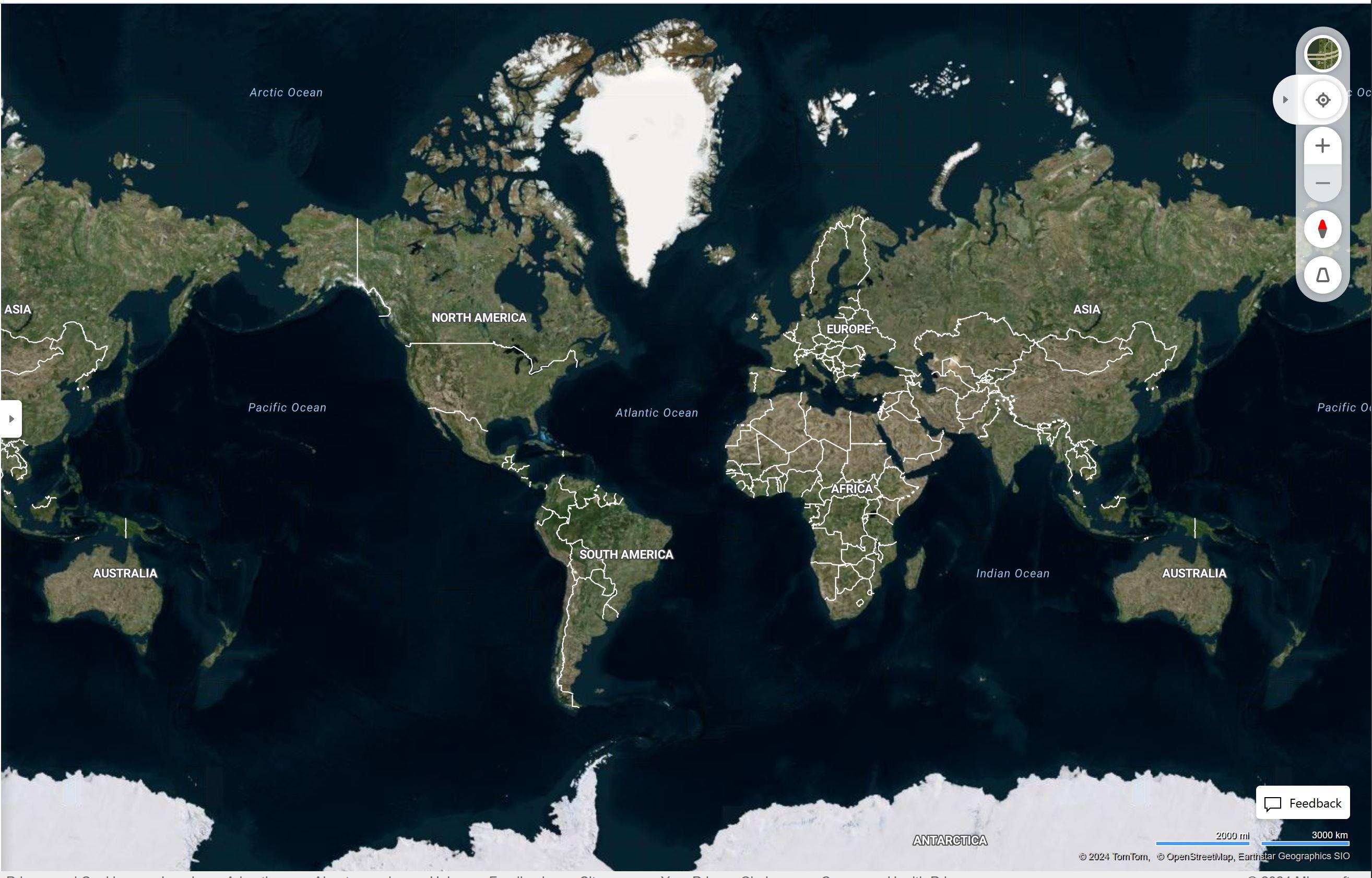
The Antarctic is colder than the Arctic, yet for some reason there is more sea ice in the north leading to it not being shown on maps. Oh, and the only glaciers depicted are in Green land, so named for reasons. And no detailed topography. That doesn’t make much sense. (media.conspiracies.win) Speculation
posted 1 year ago by Questionable 1 year ago by Questionable +8 / -2
28 comments download share
28 comments share download save hide report block hide replies
You're viewing a single comment thread. View all comments, or full comment thread.
Comments (28)
sorted by:
▲ -1 ▼
– vpnsurfer -1 points 1 year ago +2 / -3

What exactly is the issue and why is it an issue?

Have you actually looked this up ("done research") or are you just looking at a map and decide since you are ignorant or don't understand something, there must be a conspiracy?

I don't know how lasers work but I'm pretty sure it's not demons shooting colored rays.

permalink save report block reply
▲ 1 ▼
– Taitersalad 1 point 1 year ago +2 / -1

Globetard

permalink parent save report block reply
▲ 1 ▼
– Questionable [S] 1 point 1 year ago +1 / -0

https://www.youtube.com/watch?v=neUaSTSKFZc

permalink parent save report block reply
▲ -1 ▼
– vpnsurfer -1 points 1 year ago +1 / -2

Why can't I see Polaris from the Southern Hemisphere?

permalink parent save report block reply
▲ 0 ▼
– Questionable [S] 0 points 1 year ago +1 / -1

Is it because you don't live there?*

permalink parent save report block reply
▲ 2 ▼
– SuicideTruthbomber 2 points 1 year ago +2 / -0

I have been there and, alas, the stars are indeed different.

permalink parent save report block reply
▲ 0 ▼
– vpnsurfer 0 points 1 year ago +1 / -1

I have been to Southwrn Africa, Patagonia and Australia, constellations are different from where I live on the Northern Hemisphere.

You could observe the same if you wanted to.

Do you have and explanation for that?

permalink parent save report block reply
▲ 0 ▼
– freedomlogic 0 points 1 year ago +1 / -1

Lmao, lasers and demons shooting colored rays.

Something bugging you today?

Why even come here if your just going to parrot the mainstream.

And I had to look this up, because I didnt think there was no way in hell that google has laser measurements of all elevations.

https://en.wikipedia.org/wiki/Shuttle_Radar_Topography_Mission

The elevation models are arranged into tiles, each covering one degree of latitude and one degree of longitude, named according to their south western corners. For example, "n45e006" stretches from 45°N 6°E to 46°N 7°E and "s45w006" from 45°S 6°W to 44°S 5°W. The resolution of the raw data is one arcsecond (30 m along the equator) and coverage includes Africa, Europe, North America, South America, Asia, and Australia.[3] A derived one arcsecond dataset with trees and other non-terrain features removed covering Australia was made available in November 2011; the raw data are restricted for government use.[4] For the rest of the world, only three arcsecond (90 m along the equator) data are available.[2]: 4821  Each one arcsecond tile has 3,601 rows, each consisting of 3,601 16 bit bigendian cells. The dimensions of the three arcsecond tiles are 1201 x 1201. The original SRTM elevations were calculated relative to the WGS84 ellipsoid and then the EGM96 geoid separation values were added to convert to heights relative to the geoid for all the released products.[5]

The elevation datasets are affected by mountain and desert no-data areas. These amount to no more than 0.2% of the total area surveyed,[11] but can be a problem in areas of very high relief. They affect all summits over 8,000 meters, most summits over 7,000 meters, many Alpine and similar summits and ridges, and many gorges and canyons. There are some SRTM data sources which have filled these data voids, but some of these have used only interpolation from surrounding data, and may therefore be very inaccurate. If the voids are large, or completely cover summit or ridge areas, no interpolation algorithms will give satisfactory results.

So most of its from lasers, but not all of it, and its all second hand information.

Just so you know.

No demon shooting rays required. And yes I know your being sarcastic, but you sound as dumb as me when im bitching about being poisoned.

permalink parent save report block reply

GIFs

Conspiracies Wiki & Links

Conspiracies Book List

External Digital Book Libraries

Mod Logs

Honor Roll

Conspiracies.win: This is a forum for free thinking and for discussing issues which have captured your imagination. Please respect other views and opinions, and keep an open mind. Our goal is to create a fairer and more transparent world for a better future.

Community Rules: <click this link for a detailed explanation of the rules

Rule 1: Be respectful. Attack the argument, not the person.

Rule 2: Don't abuse the report function.

Rule 3: No excessive, unnecessary and/or bullying "meta" posts.

To prevent SPAM, posts from accounts younger than 4 days old, and/or with <50 points, wont appear in the feed until approved by a mod.

Disclaimer: Submissions/comments of exceptionally low quality, trolling, stalking, spam, and those submissions/comments determined to be intentionally misleading, calls to violence and/or abuse of other users here, may all be removed at moderator's discretion.

Moderators

  • Doggos
  • axolotl_peyotl
  • trinadin
  • PutinLovesCats
  • clemaneuverers
  • C
Message the Moderators

Terms of Service | Privacy Policy

2025.03.01 - j6rsh (status)

Copyright © 2024.

Terms of Service | Privacy Policy