It's a map of Eastern Europe of 900s from USSR textbooks based strictly on archaeology findings.
All Western maps depicting that period either don't have Khazarian Kaganate at all, either show giant area where Khazars do their forays against neighbours, not the real state borders where they really settled and have strongholds and towns.
Western historians don't like Khazarian Kaganate history for some reason and prefer to not touch that topic. Jews, on the opposite, like to claim that they owned everything and everywhere, as usual. None of them care about any archaeological reality and proofs.
West border of Khazarian Kaganate was on the Don river
tributaries. Most western stronghold of Kaganate was Sarkel (Sharkel) on the left bank of Don river.

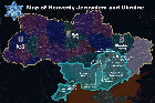
It's a map of Eastern Europe of 900s from USSR textbooks based strictly on archaeology findings.
All Western maps depicting that period either don't have Khazarian Kaganate at all, either show giant area where Khazars do their forays against neighbours, not the real state borders where they really settled and have strongholds and towns.
Western historians don't like Khazarian Kaganate history for some reason and prefer to not touch that topic. Jews, on the opposite, like to claim that they owned everything and everywhere, as usual. None of them care about any archaeological reality and proofs.
West border of Khazarian Kaganate was on the Don river tributaries. Most western stronghold of Kaganate was Sarkel (Sharkel) on the left bank of Don river.